Charleston’s Lowline project takes a major step forward
The Lowcountry Lowline will spur different opportunities, depending on who you ask. Some see a safe way to move people through downtown; or a critical piece of stormwater infrastructure; even a way to repair urban neighborhoods ripped in two by Interstate 26.
“It’s aspirational. And, a little ambitious,” Charleston Mayor John Tecklenburg told the City Paper before City Council signed off on the Lowline’s conceptual master plan on Tuesday.
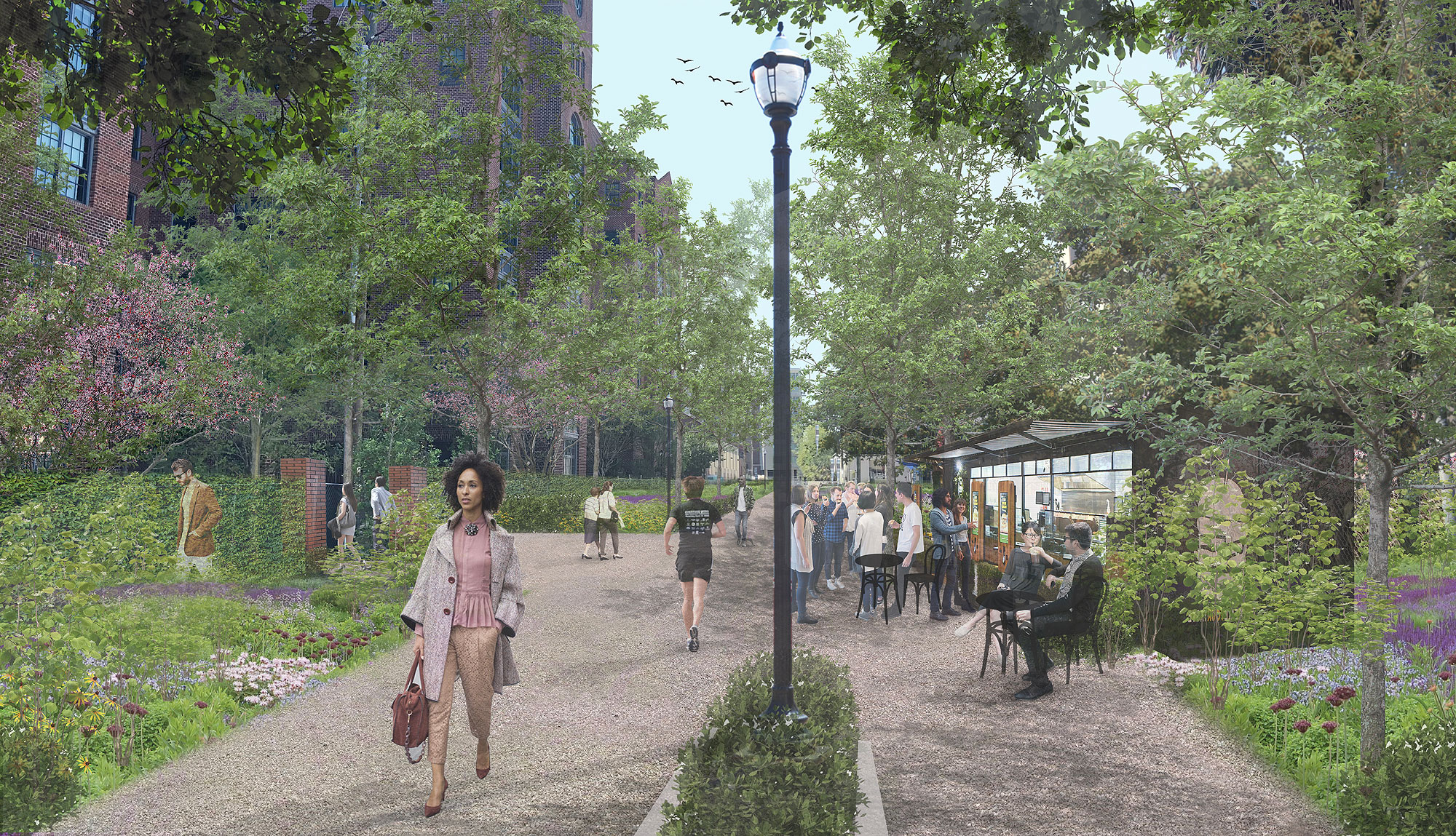
Plans for the Lowline stretch a linear park two miles from Marion Square to Mount Pleasant Street along a historic, long-abandoned railroad line. Organizers envision the space as one commuters can use to get to work and where residents can unwind at the end of the day.
Work will begin on Charleston’s most interesting park project in the coming months. Fully built, its impact could be transformative.
New renewal?
The Lowline is the latest attempt to build a park in the cavernous corridor underneath I-26. In 1976, the newly elected Mayor Joseph P. Riley built the I-26 Linear Park. Today, equipment in the Vivian Anderson Moultrie Playground sits mostly unused as trucks rumble above. A homemade skatepark grows in fits and starts.
Footpaths worn into the dirt show a lightly traveled passageway running parallel to King and Meeting streets, but bear little resemblance to the busy north-south roadways that shuttle people in and out of the city.
Where I-26 plowed across the peninsula as part of 1960s-era “urban renewal” that displaced thousands of Black families across the country, the Lowline hopes to reconnect the community.
The Lowline is planned to run two miles along a former rail line through downtown | Friends of the Lowcountry Lowline
Lowline life
Starting from its southern terminus in Marion Square, the Lowline will snake through alleyways and promenades, transforming dramatically as it winds to downtown’s northern reaches.
Plans describe three distinct progressions for the park:
• Dense urban pathways woven between restaurants and hotels will provide opportunities for pedestrian-oriented businesses a block off of the slam-packed sidewalks of upper King Street’s still-expanding business district.
• Wide-open natural spaces expand as the park moves north beneath the Ravenel Bridge overpasses, providing space for events and gatherings. Renderings show elevated walkways laced over newly renourished marshland at the head of Newmarket Creek. Purpose-built features will be designed to retain stormwater runoff in heavy storms.
• Alongside the North Central neighborhood, the Lowline settles into the wide space under I-26 and the adjacent abandoned railroad line. Organizers say the northern stretches will be an ideal place for markets, community events and leisure. Peeking onto Mount Pleasant Street, the Lowline will connect to a transportation hub serviced by CARTA and the forthcoming Lowcountry Rapid Transit line, slated to eventually provide express service to Summerville.
Bradford | Provided
“I think it will be pretty free flowing. Especially in the more northern sections of it,” said Tom Bradford, executive director of Friends of the Lowcountry Lowline, the nonprofit group spearheading the park’s construction.
“I see a place where people can come meet one another, mix and take advantage of the community in ways that are really sort of not available at this level yet in the city of Charleston,” Bradford said.
“It represents another quality of life asset to the community that will extend beyond just folks on the peninsula,” said Barney Blakeney, a reporter for The Charleston Chronicle who is on the Lowline board. “The residents will decide what this thing will look like, ultimately.”
Also folded into plans for the Lowline are millions of dollars to handle sudden stormwater surges downtown. Large portions of the project will be designed to retain water in heavy rains, creating temporary impoundments for surface runoff.
The Lowline property as it exists today
The Lowline will transform an abandoned railway into an expansive park that also alleviates downtown stormwater issues | Images provided
City planners working with Friends of the Lowline foresee early progress where investment is already taking shape.
“It’s based on a couple things: availability of funding and applicability of funding, where things are already starting to happen and where things will likely happen — leveraging pending investment,” said Allen Davis, director of Charleston’s Civic Design Center.
Davis | Provided
Initially, that means areas between Spring and Line streets will likely be where some of the initial new stretches of the Lowline will be constructed, with some builders taking on improvements themselves, according to Davis.
Starting early next year, Bradford said his group will work with the city to secure preliminary funding to continue development.
Friends of the Lowline will have to take the wheel as plans take shape to reduce workload on city staff, Davis said.
“One of the biggest challenges is going to be figuring out how to create a public-private partnership that relies on the Friends of the Lowline to grow into a project delivery and maintenance entity, similar to the [Charleston] Parks Conservancy model,” Davis said.
Early estimates put the cost of the project around $36.5 million, with roughly a third dedicated to stormwater infrastructure. Some funding will come from city tax-increment financing, with the rest coming from grants, donations and deals with developers as part of the build-out. A big to-do list item, Bradford said, is developing piecemeal revenue sources along the parkway to keep the Lowline self-sustaining.
Tecklenburg called the master plan a good starting point, but knows the finances will be tough heading into a year with an $18 million shortfall from the coronavirus pandemic.
“Putting together the funding sources to make that happen, will be a little bit of a challenge,” he said. “Like trying to eat the elephant, we’re gonna have to do it a bite at a time.”
A cool spot
Blakeney remembers walking to school under I-26 as a teenager, growing up a block away on Sans Souci Street.
Blakeney | Photo provided
“Even on the hottest days in the summer, beneath that overpass was always one of the coolest spots in the city,” Blakeney said.
Since then, he’s watched the area change, with demographics shifting in the once-majority-Black neighborhood.
Even Bradford acknowledges the project’s potential to gentrify nearby neighborhoods as property values nudge longtime residents to take the money and run.
So, how can the city and Friends of the Lowline mitigate potential negative impacts of a pretty new urban park in neighborhoods long impacted by haphazard urban renewal?
“Simply put, provide more affordable housing,” Tecklenburg said.
The city is currently in the planning stages of one project to build 55-70 affordable apartments alongside the Lowline. Elsewhere, high-end private complexes will be required to provide a handful of additional units. But, those efforts will likely still fall short of what’s said to be needed. The Charleston Metro Chamber of Commerce estimated in 2019 that more than 7,000 new housing units will be required each year in a good economy, with roughly half needing to be below market rate.
Bradford said the Friends of the Lowline is also undertaking a community history project in an effort to incorporate the nearby neighborhoods into the park.
Blakeney does not think the Lowline will have any added negaive impact on the neighborhood that it would not otherwise feel. That does not mean it’s too late for Black residents to benefit from the latest “quality of life asset” to spring up as development moves in.
“I’d really like to hear people talk about minority business development … as it relates to the Lowline,” Blakeney said.
“This thing is going to happen,” Blakeney said. “What part are [Black people] going to play in this reality?”
Making connections
Mobility advocates see the Lowline as a critical way to expand Charleston’s transportation options.
Zimmerman | Photo provided
“I think the more actual infrastructure you have in place, that that dedicates or acknowledges space for people to walk and bike or take the bus, I think that it’s a visual reminder for everybody that there are these other modes of transportation that need to be respected and need to be protected,” said Katie Zimmerman, executive director of Charleston Moves.
The route also provides safe passage down the length of the peninsula. Now, Zimmerman said, a ride from the Hampton Park Terrace neighborhood to Marion Square has the potential to be “panic-inducing.”
With a connection to CARTA at the planned Mount Pleasant Street transit hub, Lowcountry Rapid Transit strategist Daniel Brock said the Lowline could be key for park-and-ride commuters.
“I think what this does is start to create an entire network of transportation alternatives on the peninsula, where you’re looking at public transit in various modes,” Brock said. “And then, you’ve got a world-class [bicycle and pedestrian] facility running down the center of the peninsula.”
Bradford has high hopes for a barebones Lowline to be in use within the next three years, “if not completely polished,” with improvements to come along the way as funding permits.